


Vatnahalsen-Flåm
Brekkefossen

Høgebru

Flåm Old Church

Rjoandefossen
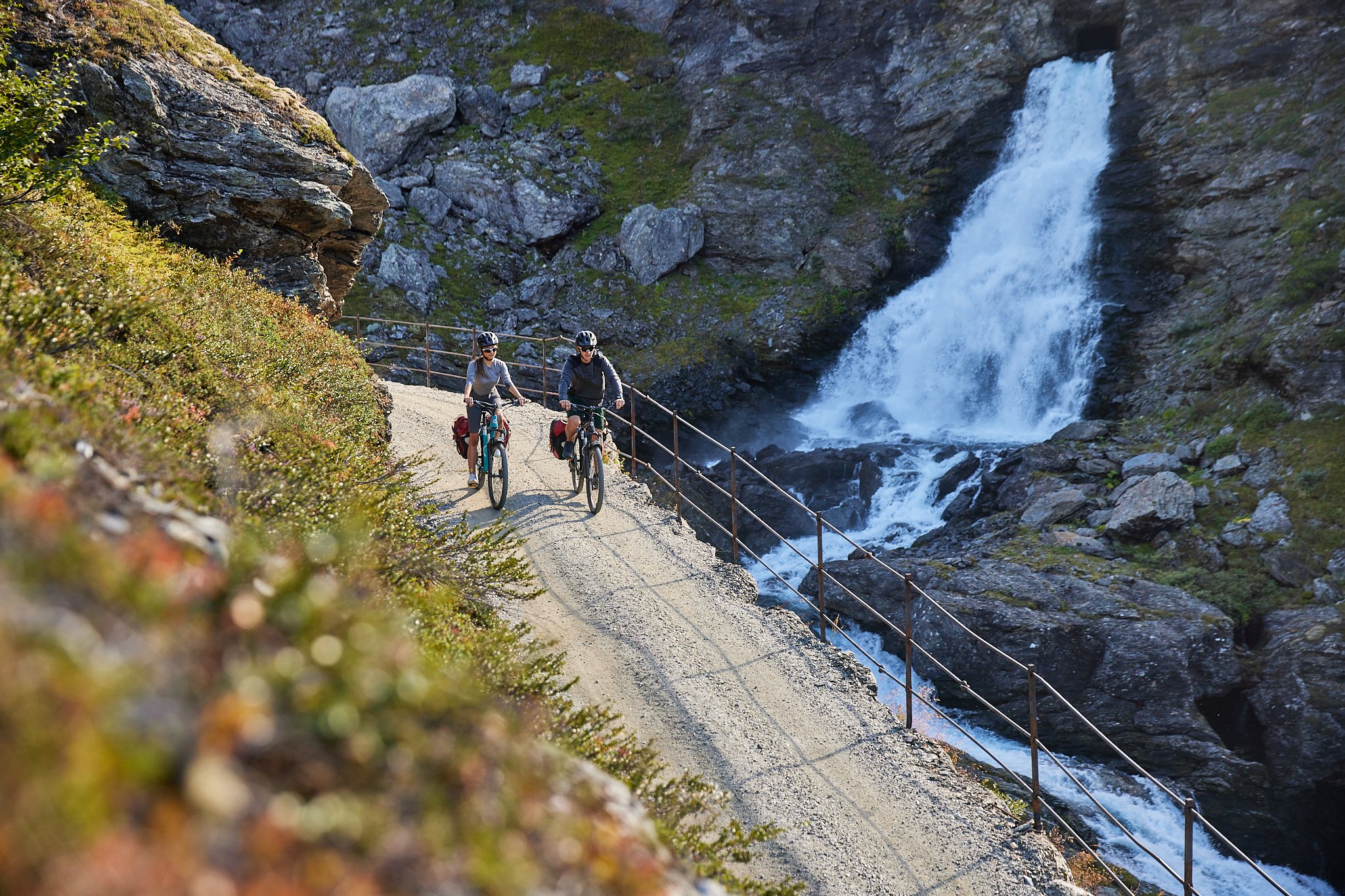
Rallarvegen

Otternes

Stegastein Viewpoint

Aurland
Otternes
About:
Exploring Otternes offers visitors a quiet and charming glimpse into Norway's rural heritage. Nestled in the scenic landscapes surrounding Flåm, Otternes is a historic cluster of well-preserved, traditional farmsteads that date back several centuries.
A leisurely stroll through Otternes allows tourists to step back in time and experience the simplicity of life in rural Norway. The cluster of old farmhouses, barns, and outbuildings showcases the architectural style and craftsmanship of a bygone era. The picturesque setting, with lush green fields and panoramic views of the surrounding mountains, adds to the idyllic charm of Otternes.
Unlike grand attractions, Otternes offers a more low-key, yet authentic, experience. Visitors can meander through the narrow pathways, exploring the details of the well-maintained structures and gaining insight into the agrarian lifestyle of the past. The tranquil atmosphere and rustic beauty make Otternes a delightful stop for those seeking a break from the hustle and bustle of more touristy destinations.
In essence, a visit to Otternes is like stepping into a living museum, where the simplicity of rural life and the beauty of the Norwegian countryside come together. For tourists seeking a peaceful and authentic experience, Otternes in Flåm offers a quiet retreat into the past, allowing for a deeper connection with Norway's cultural heritage.
The Ride:
Distance: 4.3 km one way.
Riding time without stopping: Approx 25 min.
Designated bikepath: Yes, designated bikepath beside the highway. Only the last part is on a steep gravelroad. (be careful when crossing the highway, there could be cars/trucks driving fast).
Steep climb/descent: 102m climb. (flat until the last hill up to Otternes).
Google map link: https://maps.app.goo.gl/veuHijHVXKHbobVT6
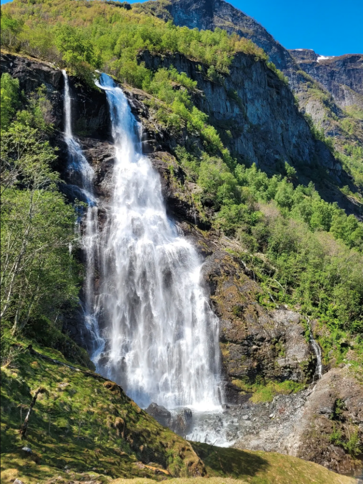
Brekkefossen
About:
Brekkefossen offers a serene and captivating experience for tourists seeking a taste of Norway's natural beauty. Tucked away in the scenic surroundings, but very close to Flåm citycenter this majestic waterfall provides a tranquil escape into the heart of the Norwegian wilderness.
Its a short bikeride to the trailhead where you can either look at the waterfall from the road, or park your bike and continue the hike up to the waterfall. Its. steep climb, but its well worth the physical effort!
Whether you're a casual observer, a nature enthusiast, or someone looking for a peaceful retreat, Brekkefossen offers a low-key yet delightful excursion that showcases the natural allure of Flåm.
The Ride:
Distance: 2 km one way to the trailhead.
Riding time without stopping: Approx 5 min.
Designated bikepath: No, but not a lot of traffic on this road.
Steep climb/descent: 10m climb (but more if you are planning on hiking to the viewpoint at the bottom of the waterfall.
Google map link: https://maps.app.goo.gl/Jr8SiGZbKXa3P1as7
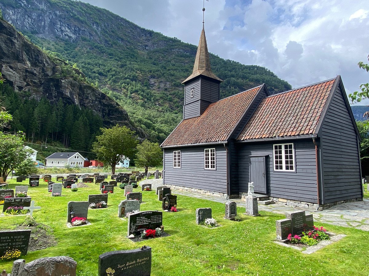
Flåm Old Church
About:
Built in the distinctive stave church style, Flåm Church dates back to the late 17th century, showcasing the traditional craftsmanship and design that has characterized Norwegian churches for centuries. Its intricate wooden structure, with steep roofs and carved details, adds a sense of charm and authenticity to the surrounding natural beauty.
Stepping inside Flåm Church, you'll find yourself enveloped in an atmosphere of tranquility and reverence. The interior is adorned with beautiful religious artifacts, ancient wooden furnishings, and a warm ambiance that invites contemplation. As you explore the church, you'll gain insight into the local community's enduring connection with faith and tradition.
Beyond its religious significance, Flåm Church offers a unique vantage point to appreciate the stunning landscapes that define the region. Positioned against the backdrop of majestic mountains and the tranquil waters of the Aurlandsfjord, the church provides an excellent opportunity to capture postcard-worthy photographs and create lasting memories of your visit to Flåm.
The Ride:
Distance: 3.5 km one way.
Riding time without stopping: Approx 10 min.
Designated bikepath: No, but not a lot of traffic on this road.
Steep climb/descent: 28m climb
Google map link: https://maps.app.goo.gl/8F7Q1g8cycnYvw6m8
Vatnahalsen/Myrdal-Flåm
About:
This scenic route is perfect if you want to get higher up in the mountains, and see more than just the fjords.
Starting at Vatnahalsen, situated high in the mountains, the bike ride descends through a picturesque valley treating cyclists to breathtaking views of lush greenery, cascading waterfalls, and snow-capped peaks if you are riding in May and June. The crisp mountain air and the scent of birch trees create an exhilarating backdrop for the ride.
As you pedal along, the trail reveals glimpses of charming mountain farms and traditional Norwegian architecture, adding a cultural touch to the outdoor adventure.
The ride starts with 21 steep switchbacks. Its very steep, and rocky. We strongly reccommend to walk this section. Children need to be very comfortable on a bike to ride this section, and our general advice is not to ride it with children younger than 12 years.
One of the highlights of the journey is the descent into Flåm, where the landscape transforms from alpine terrain to the lush fjord environment. The gradual change in scenery, from mountainous terrain to the serene Aurlandsfjord, provides a dynamic and visually captivating experience.
For those who appreciate an active exploration of nature, this journey offers an opportunity to feel the wind in your hair and experience the changing landscapes of Norway in a unique and immersive way.
Whether you're a seasoned cyclist or a casual adventurer, the bike ride from Vatnahalsen to Flåm is a memorable and picturesque experience, offering a perfect blend of outdoor activity and the beauty of Norway's natural wonders.
Riding the opposite way on an electric bike on this route is fantastic. You see more than you do from the train, and enjoy different views going uphill. We do not recommend to ride the switchbacks towards Vatnahalsen uphill as they are very technical.
The Ride:
Distance: 18 km one way.
Riding time without stopping: Approx two hours riding. (+ train to get to Myrdal)
Designated bikepath: Only biking/hiking the first part, and then you can meet cars coming up the valley. The road is steep and narrow in places, so we STRONGLY recommend to ride slowly.
Steep climb/descent: 800m decent.
Google map link: https://maps.app.goo.gl/zmzPrekknJA6Yaj3A
Rjoandefossen
About:
Embarking on a bike ride from Flåm to Rjoandefossen offers a serene journey through the captivating fjord landscape.
Its a fairly short route, but with a steep uphill right after Flåm Old Church. If you are not used to biking an electric bike is reccommended.
Upon reaching Rjoandefossen, cyclists are greeted by the majestic waterfall, creating a moment of quiet admiration. The mist generated by the falling water adds a refreshing element to the experience, complementing the overall sense of tranquility.
The return journey to Flåm offers an opportunity to savor the landscapes from a different angle, ensuring a rewarding and memorable adventure in the heart of Norway's fjord region.
The Ride:
Distance: 5.4 km one way.
Riding time without stopping: Approx 35 min with a touring bike, and 15-20 with an ebike.
Designated bikepath: No, but not a lot of traffic on this road.
Steep climb/descent: 104m climb
Google map link: https://maps.app.goo.gl/FV4uusFK2zWNZJmN8
Høgabru (cave waterfall)
About:
This little sweetspot is located 8 km from Flåm.
Enjoy the spectacular view from the bridge with river coming trough the mountain. You can see the cave from both sides if you ride above the bride, and cross the train tracks.
It goes without saying, but stay on the road and dont climb down towards the waterfall!
The Ride:
Distance: 7.8 km one way.
Riding time without stopping: 1.5 hour with a touring bike, and 30 minutes with electric bike.
Designated bikepath: No, but not a lot of traffic on this road.
Steep climb/descent: 225 meter climb.
Google map link: https://maps.app.goo.gl/gaBqHKwFSEohX5ZS9
Stegastein viewpoint
About:
Our general advice is not to ride here on a bike due to the road conditions. But we still have a lot of customers doing it, so we want to give some advice here if you decide to do it anyway.
Please see the “designated bikepath” part for more info.
The Stegastein viewpoint is stunning with its fantastic view over the Aurlandsfjord. It sits 650 meter above sealevel, and is a very steep climb on a bike.
If you plan on biking there electric bike is almost mandatory. (or you have to be very fit, and prepared for a steep climb).
If you still have energy after reaching the viewpoint the road continues higher up the mountain.
There are daily sightseeing buses leaving Flåm if you want to visit Stegastein without a bike.
The Ride:
Distance: 16 km one way.
Riding time without stopping: 1.5 hours one way on an electric bike, and 3 hours on a touring bike.
Designated bikepath: The first 4 km are on a designated bikepath. For the rest of the trip you are various different roads. It start of with a highway with a lot of trucks and cars. This road has little or no shoulder, so when two trucks are meeting there is not enough space for a cyclist.
The climb up to Stegastein from Aurland is very narrow at times. There are a lot of cars and buses driving here in peak season so please be aware of cars.
climb/descent: 694 m climb
Google map link: https://maps.app.goo.gl/b1MtHaM2BBGC5yUs6
Visit Flåm / Sverre Hjørnevik

Aurland
About:
Our general advice is not to ride here on a bike. But we still have customers doing it, so we want to give some advice here if you decide to do it anyway.
Please see the “designated bikepath” part for more info.
The town of Aurland offers scenic fjordviews. There are various shops, and a bigger supermarked than in Flåm.
Dont miss the “Aurlandskoen” factory where they make the traditional Aurland penny loafer shoe.
The Ride:
Distance: 8 km one way to the trailhead.
Riding time without stopping: Approx 40 min on a touring bike, and 20 on an electric bike. (each way)
Designated bikepath: The first 4 km are on a designated bikepath. For the rest of the trip you are various different roads. It start of with a highway with a lot of trucks and cars. This road has little or no shoulder, so when two trucks are meeting there is not enough space for a cyclist.
Steep climb/descent: 65m climb and 51 m decent.
Google map link: https://maps.app.goo.gl/Jr8SiGZbKXa3P1as7